How a former monopoly is staying competitive by using intelligent mapping to give the best services nationwide to over 20 million internet and landline customers
Client: Turk Telekom: 20 million total subscribers, 34,000 employees, 500,000 km of cable
Challenge: Data on millions of customers and thousands of km of cable, with no integrated
way to analyze or update them; company restructuring and workforce changing
Solution:Mapbis scalable GIS environment, synthesizing all data into an instantly updatable
system providing easy monitoring, analyses and planning, plus ongoing on-site staff
support (100 people)

Client background and challenge
Turk Telekom (TT) was formerly a monopoly provider of telecommunications services in Turkey. TT was privatized in 2005 and since then has developed a new corporate strategy in light of the global trend toward GSM for telephone services. The challenge has been fourfold: first, to convert paper maps to a digital, analyzable format; second, to plan network upgrades to fiber optics for the greatest return on investment; third, to use a real time updatable system for guiding the sales team to potential new customers and to current customers for service upgrades; and fourth, to integrate all these into a single, easy to use, digital environment.
Solution
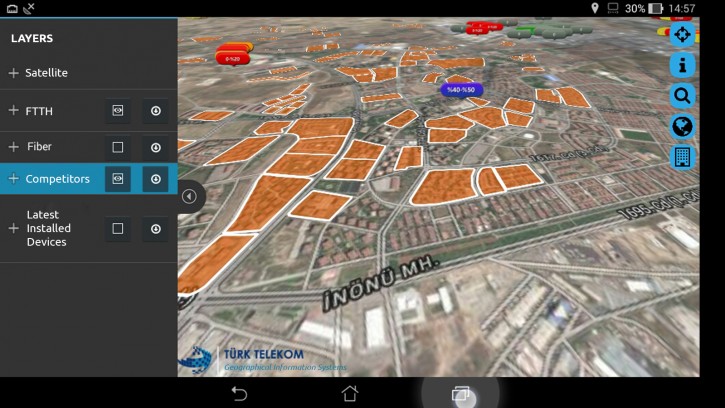
Mapbis enabled Turk Telekom to pursue the new strategy by providing a software environment that unifies all operations geographically. Mapbis also provided an on-site support team for startup and ongoing development. This way, Turk Telekom became able to extract the maximum information from its paper maps while integrating them into a digitally zoomable, searchable environment. Decisions on new fiber optic lines in the network now can be made strategically. Customer data now can be updated in real time and analyzed at any scale, and now are integrated with all other available knowledge for instant use by Turk Telekom.
What did Turk Telekom gain by working with Mapbis?
-
- A framework contract was signed with TT, in which Mapbis provided a technical staff to work together with TT staff for development and continued support
- Hundreds of thousands of maps (as-built, network, service areas) were digitized with Mapbis easy to use, specially designed desktop applications
- TT gained a comprehensive, detailed digital map of their entire physical network, searchable and zoomable at any scale, showing all copper and fiber optic lines and all information previously displayed on separate paper maps
- Network status updates in real time: field maintenance and strategic planning are now integrated via comprehensive, reliable information
“Since GIS implementation, Turk Telekom has become confident of its infrastructure, and new investments are planned more reliably. This saves a lot of money and time.”
Murat Altparmak
GIS Manager
Turk Telekom
- Former government monopoly in Turkey
- Privatized in 2005; subsidiaries include
TTNet, Avea, Innova - Services Broadband internet: 7.5 million subscribers
Landline phone: 13.5 million subscribers - Network
- ~ 330,000 km copper
- ~ 180,000 km fiber optic
- ~ 3.5 million customer distribution boxes
- ~ 780,000 km2 service area
- Actively converting network to fiber optics
Technology used
- Oracle Spatial
- MapInfo Pro, MapXtreme .Net


- Geography based, real time updated entry of current and new customer data: TT became able to precisely geocode its 20 million customers on the map, by postal address and network topology, for spatial decision making in marketing and sales
- Individual customer broadband speed maps were created, based on real network
distances and measurements: with these, provided speed can now be checked against subscription speed; financial advantages of speed-upgrade sales campaigns are now easy to calculate - Daily statistics on inventory and new installations are now reported to TT
management and to stock exchanges; this way, payments to installation contractors are also kept up to date - Geography based synthesis of all available knowledge: all data became clear and accessible, even as the workforce was being restructured, thus saving time, maximizing network speed and service quality, and increasing profit
Where next?
Turk Telekom, using Mapbis integrated GIS environment, is now expanding its high speed internet and IPTV coverage with up-to- date broadband speed maps. Potential customers are being identified within individual buildings, and TT sales force can confidently offer new or upgraded services based on the maps. TT is starting to use a new field force management system(4000+ staff) in which Mapbis navigation maps are combined with TT network and customer maps, to speed up response time and increase customer satisfaction, and to reduce costs. TT is now combining all these new capabilities in a dashboard display, making all data instantly available for managing daily operations and forming short, middle and long range strategic plans.


