Client: Kayseri Water: 510 000 subscribers, 500 employees, 3 700 km of pipe in network
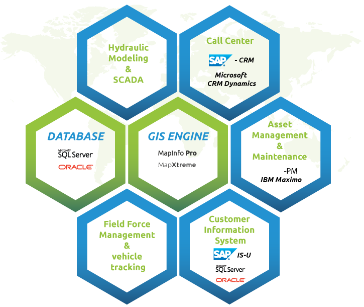
Challenge: Integrate fragmented data from all operations (customer relations, physical network, etc) in a unified, easy to use digital environment
Solution:HydronetMaestroA data environment, specially designed for managing water networks


With the HydronetMaestro web and desktop applications, access to infrastructure and customer information became faster
Salim TUNCAY
Kayseri Water GIS Director
use HydronetMaestro, a data environment designed specifically for managing water and wastewater distribution systems.
The key to combining diverse data involved in water distribution is the approach known as geographic information systems (GIS). In GIS, all data are associated with geographic coordinates. This way, diverse types of data become integrated into a single, zoomable, searchable environment.
- Manage network inventory, maintenance status
and connectivity in real time - Increase customer satisfaction by integrating customer addresses, field crew work schedules and local service status
- Web-based applications for marketing and sales management and spatial decision-making
- Each customer was located by correct address superimposed on the network map, enabling individual or category statistics to be generated at any scale
- Improve workflow throughout the organization, because everyone uses the same integrated system via controlled accounts
- Clean, simple design
- Customized tools make HydronetMaestro easy to use for all employees, from managers to maintenance crews
- Zoomable to any scale, from international to a single customeras address
- Advanced analyses can be performed easily and intuitively, according to whatever categories the user defines
- Each employeeas access is password controlled, and file permissions can be managed to keep data reliable and safe
Technology used
- Oracle Spatial
- MapInfo, MapXtreme, .Net
- Yolbil Navigation of Mapbis

